|
Stardate
20031029.0039 (Captain's log): I'm afraid that the fact that I'm here in San Diego doesn't really put me in a position to know any more about the fires than anyone else. I rely on the same news sources you do, and the last thing that the fire crews need is some pesky blogger playing reporter-for-a-day. But I've received mail from people worrying about me, so I wanted to make clear why I don't think I'm at risk.
I just found this map on the web site for the San Diego Union Tribune:
They didn't include a scale, and it's not really clear how big the burned area is unless you're familiar with this area. So just for reference, it's about 50 miles from Oceanside to the Mexican border.
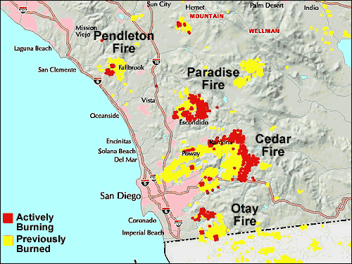
On this map, the pink areas are heavily settled, and early firefighting concentrated on stopping the westward movement of the fires. But there are a lot of houses in the non-pink areas, too. Or at least, there used to be, in some of the non-pink areas which are now yellow.
They also had this map, which includes a lot more detail of a smaller area as it was Monday evening, about 30 hours ago as I write this. What it shows is that the part that burned the furthest west was inside the Miramar Marine base, and it was stopped before it reached the airfield and the most important facilities there. The part of the base that burned is pretty much wide open and unused.
That was also the closest the fire got to me. I live just east of Del Mar, and that area is about 8 miles SSE from my home. Barring new outbreaks of fire, I should be OK. (But since they now suspect arson, new outbreaks of fire can't be ruled out.)
I'm grateful that we were not threatened, and I feel very sorry for everyone whose homes have been destroyed. I also feel sorry for the Indians in the Barona reservation, which appears to have been entirely burned. I haven't seen anything yet in the news about their casino, but it's highly unlikely that it survived.
It's hard to tell for sure from the above map, but it also looks as if the Viejas reservation (and their casino) was destroyed. It's just north of Interstate 8 right where that big red (burning) area touches it. It looks as if the firefighters have been trying to use the interstates as natural fire-breaks, which makes a lot of sense, and I-8 is a good one. I was actually surprised to see that the fire managed to hop I-15, which is about 12 lanes through there.
Anyway, the Viejas reservation is on the north side of I-8, so the highway doesn't defend them. But the casino is right next to the highway, and there may have been an effort to try to save it. I hope so; it's the only important source of income the tribe has.
[Note for non-Americans: odd-numbered interstates run more or less north-south. Even-numbered ones run approximately east-west. The primary interstates all have numbers between 1 and 99, and the numbers are assigned based approximately on a coordinate system starting from the SW corner of the continental US. So the primary interstates here are I-5, I-15 and I-8. I-5 runs north along the coast to LA, and then through Sacramento. I-15 runs north from San Diego past LA on the east, then into Nevada and through Las Vegas. I-8 runs east from here and ends in Arizona. When small extra segments are needed, they're assigned numbers in the hundreds, so I-805 is east of I-5 and runs parallel to it from the Mexican border to a point just south of my home.]
It looks as if the east edge of the Cedar fire has already burned its way through the Capitan Grande reservation, and right now it is in the process of destroying some parts of the Cleveland National Forest which are north of I-8. Continuing east there ain't a hell of a lot; a couple tiny Indian reservations, a state park, and a lot of God-forsaken wasteland that no one gives a damn about, and then the Salton Sea, which should be pretty effective at stopping the blaze if it gets that far. The north part of the Cedar fire is threatening the town of Julian, about which I know nothing. Meanwhile, if the Paradise fire burns another ten miles north it's going to destroy the Palomar observatory and two more Indian reservations. And in that happy zone between the Paradise and Cedar fires, threatened from both sides, there are another two reservations. And there are little towns all over the place out there. A lot more people are going to lose their homes before this is over, and all we can hope is that they don't lose their lives, too. The California Department of Forestry and Fire Protection predicts that the Cedar Fire won't be fully contained until November 5, by which point it may well have burned all the way to the Salton Sea.
What's amazing to me about that map is how many small fires have already been put out. If it was arson, they were busy little firebugs.
I should note that the Cedar fire is thought to have been caused by an idiot hunter who got lost and started a signal fire. The Pendleton fire (which was entirely within Camp Pendleton) was started during a Marine training exercise. But that doesn't mean others weren't started deliberately. And it's hard to believe that so many fires could have started in so brief a period just by accident, even if a Santa Ana wind increased the fire hazard.
The LA Times reports that the LA County Sheriff
|